
This Week in History
November 17-23, 1811: Construction Begins
on the National Road to the West
November 2013
In colonial America, the condition of the roads was generally so terrible that most people preferred to travel by water—either up and down the Atlantic coast, or by river. But when America won her independence and the new nation expanded westward, it was difficult to navigate any boat beyond the "fall line" of the major rivers, where they approached the Eastern mountain chain. To cross the mountains, Americans went by foot or on horseback, following, as did the Indians, the old buffalo migration trails, which took the easiest routes.
One of these well-known trails was called Nemacolin's Path, named for the Indian who helped Western scout Christopher Gist widen the trail so that settlers could reach Ohio Company lands near what is now Pittsburgh. The Washington family was the leading sponsor of this effort, and when the French burned the settlement on the Youghiogheny River, young George Washington supervised the widening of the road. His Virginia and North Carolina troops, who marched on that road, were badly outnumbered by the French and their Indian allies, and suffered a military defeat at the Great Meadows in 1754.
Britain was forced to answer the French action, and sent Gen. Edward Braddock to capture the French-held fort at the fork of the Ohio River. Thus, Nemacolin's Path and Washington's Road became Braddock's Road, and it led to the Ohio River and thus to the vast Mississippi Basin. But the road ran through an almost impenetrable forest, cleared to only 12 feet wide, and plunged and climbed through the wilderness at often death-defying angles. It would not do for commerce, nor for delivering the United States mail.
When Thomas Jefferson became President in 1801, the territory of Ohio was well on its way to becoming a state, and there was a pressing need for better communication with the expanding population west of the Allegheny Mountains. The U.S. Constitution gave the government the power to "establish post-offices and post-roads," but there was an ongoing debate in Congress over whether the Federal government actually had the power to build the roads. In December of 1805, the Senate passed legislation which made the construction of the national road to the Ohio River a Federal project, and it specified that the money to finance the construction would come from 5% of the proceeds from selling the Federal lands in the Northwest Territory to settlers. This procedure was followed as the road was extended to Columbus, Indianapolis, and eventually to Vandalia, the early capital of Illinois.
 National Road sign in Richmond, Indiana.
|
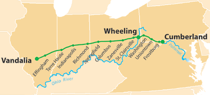 National Road map.
|
|
|
Picture credits: Left: Peetlesnumber1 at Wikimedia Commons. Licensed under the Creative Commons Attribution-Share Alike 3.0 Unported license. Right: Citynoise at Wikimedia Commons. Licensed under the Creative Commons Attribution-Share Alike 2.5 Generic license
|
||
The first section of the national road was known as the Cumberland Road because it began at Cumberland, Maryland, the base camp for both the Ohio Company and General Braddock's expedition. Congress provided for a three-man Cumberland Road Commission to oversee construction and maintenance, and to map out the route of the road. The general route adopted was that of Nemacolin, Washington, and Braddock, but the ultimate destination was Wheeling, further down on the Ohio River than Pittsburgh.
|
Wikimedia Commons. Released into the public domain by its author, Jstuby
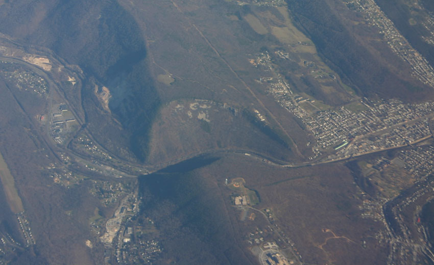
Aerial view of the Cumberland Narrows, northwest of Cumberland, Maryland, where Wills Creek, a branch of the Potomac River, passes though a break in a ridge of the Allegheny mountains. The National Road followed the creek through the Cumberland Narrows, but had to climb some of the Allegheny ridges at an oblique angle
|
Congress also set out specifications for the road, such as a 66-foot cleared width and a maximum grade of five degrees, or 8.75%, a very difficult requirement for mountainous terrain. In the summer of 1806, President Jefferson appointed Thomas Moore and Elie Williams of Maryland, and Joseph Kerr of Ohio, as the three commissioners, and they were sent westward to map out the route, along with two surveyors, two chain carriers, and two helpers. By the first week of December, they had done most of the work and were running into severe winter weather. Consequently, they sent a report and maps to President Jefferson and told him they would consult with him in Washington.
In their report, the commissioners wrote that the task of determining the route had become "a work of greater magnitude, and a task much more arduous, than was conceived before entering upon it." Not only was every locality and village begging them to bring the road in their direction, but the five degree requirement for the grade of the road was making the choice of route over the high Alleghenies very difficult.
The demands of the localities were not within the commissioners' purview, but they did find a way to solve the engineering difficulty: "The face of the country within the limits prescribed is generally very uneven, and in many places broken by a succession of high mountains and deep hollows, too formidable to be reduced within five degrees of the horizon except by crossing them obliquely, a mode which, although it imposes a heavy task of hill-side digging, obviates generally the necessity of reducing hills and filling hollows, which, on these grounds, would be an attempt truly Quixotic." Thus, the route followed horseshoe curves at the mountains, but ran straight ahead where grade was not a factor.
By the end of 1808, contracts were let out for clearing the right of way for the road, and the final surveying was completed to Wheeling. But actual construction did not begin until fall of 1811, and on Nov. 20, the road out of Cumberland reached the top of the Allegheny Front. The outbreak of the War of 1812 halted construction, but after the war it was resumed, and by 1818, the road was all but complete to Wheeling, and the first mail coaches began rumbling westward to the Ohio.
The road was greeted with enthusiasm when it came through any area. A farmer who lived near the construction site recorded that the workers came "a thousand strong with their carts, wheel-barrows, picks, shovels, and blasting tools, grading those commons, and climbing the mountain-side, leaving behind them a roadway good enough for an emperor to travel over."
After boulders were hauled away, trees were toppled, stumps pulled, roots grubbed out, and underbrush cut back, the workers would have a clearing 66 feet wide in which to construct the road. Ditches were dug along either side, leaving a sloped cradle 32 feet wide in the center. A 20-foot-wide section of that cradle was then dug out to a depth of 18 inches at the center and 12 inches at the sides. This was first filled with hand-crushed seven-inch stone, then by three-inch stone, and then by a surface of sand or gravel which was compressed by a three-tone roller.
The minute a new section was completed, the residents of the area would drive their horses, carriages, and wagons on it, often catching up to the work crew ahead and mixing in with their equipment. This ability to use the road immediately created more and more public support for the project, as was to happen in the not-too-distant future when the less difficult center section of the Erie Canal was built first, and every owner of a boat in upstate New York launched it on the canal.
Once the road was completed, the Conestoga wagons came into their own. The floor of a Conestoga sloped sharply upward on both ends to prevent people and goods from spilling out on steep slopes. The wagons were used by pioneers heading westward, but they were also freight carriers driven by wagon drivers who were legendary for smoking cigars as they handled the reins. These cigars were so ubiquitous among the Conestoga drivers that they acquired the nickname of "stogies."
Before the construction of the National Road, it took eight days to travel from Baltimore to Wheeling; the time was reduced to three days once the road was opened. By 1828, the city of Wheeling sent 1,750 tons of produce to Baltimore in over 1,000 wagons. Towns and villages multiplied near the road, the value of property increased, and local roads were built to provide access to the National Road.
Thomas B. Searight, whose father was a contractor for some sections of the National Road and served as a commissioner for Pennsylvania, wrote his reminiscences of the road during the 1830s to 1850s. "As many as 20 four-horse coaches have been counted in line at one time on the road," he remembered, "and large, broad-wheeled wagons, covered with white canvass stretched over bows, laden with merchandise and drawn by six Conestoga horses, were visible all the day long at every point, and many times until late in the evening, besides innumerable caravans of horses, mules, cattle, hogs, and sheep. It looked more like the leading avenue of a great city than a road through rural districts."
In 1844, the new Baltimore and Ohio Railroad reached Cumberland, and passengers then transferred to stagecoaches to travel the National Road. But soon the railroad reached Wheeling, and travel on the road became more local. John Lewis Peyton of Virginia, who had kept a diary of his journey on the road in 1848, published his observations in 1869. "At this day," he wrote, "a railway has been constructed across these Virginian Alps, rivaling in its grades and physical difficulties surmounted, that of Mount Cenis. Where the savage trod in 1755, and the stage-coach dragged its slow length along in 1848, the trains sweeps by in 1869, bearing thousands of passengers daily on their journeys, and transporting hundreds of thousands of tons of freight. We live in a fast age it must be allowed. Old things have passed away—all things become new."
The original article was published in the EIR Online’s Electronic Intelligence Weekly, as part of an ongoing series on history, with a special emphasis on American history. We are reprinting and updating these articles now to assist our readers in understanding of the American System of Economy.