
North American Water and Power Alliance (NAWAPA)
Click here for 1983 Article on NAWAPA
by Lyndon LaRouche
added as Appendix to 1988 Schiller Institute
Conference Proceedings
in Andover, New Hampshire
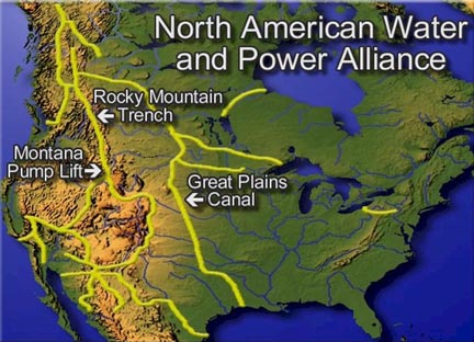
This map of the 1960s "North American Water and Power Alliance" (NAWAPA) shows the continental scale of the needed water supply improvements in North America, and also makes the point on how behind and backward the economies of the United States, Canada, and Mexico have needlessly become under 30 years of anti-development "free market" policies. For three decades, while the amount of money poured into mergers, speculation, and the "markets" rose, investment in infrastructure, industry, and agriculture slowed down to nothing.
"Soft infrastructure" has likewise been shorted, and ratios are dropping of per-household numbers of hospital beds, diagnostic equipment, etc.
The NAWAPA Project shown here, was drawn up by the Pasadena, Calif.-based firm of Ralph M. Parsons Co., and favorably reviewed by Congress in the 1960s for completion by the 1990s, but it was never begun. The idea is to divert southward some 15% of the MacKenzie River (northern Canada) runoff now going towards the Arctic, channelling it through the 500-mile Rocky Mountain trench, then along various routes, eventually reaching even Mexico. The broken lines show new, navigable canals.
The principle--on a grander scale--is the same as that of the Tennessee Valley Authority of the 1930s, and the 1950s St. Lawrence Seaway, both shown on the map. NAWAPA could supply an additional 135 billion gallons of fresh water to the United States, Canada, and Mexico, plus power, and vast new areas of cultivation. It would involve thousands of skilled jobs to construct and operate.
When you visualize overlays on this NAWAPA map, of expanded rail links, magnetically levitated routes, upgraded levees, and new power, water, and mass transit for cities, plus refurbished farm regions, you begin to see the vast overdue projects and potential at home in North America.
Nuclear NAWAPA XXI, Desalination, and the New Economy (EIR) September 2013
CONFERENCE TRANSCRIPT: Hal Cooper: The Extended NAWAPA: World Rail and Nuclear Power. Schiller Institute Conference, San Francisco, June 29, 2013
LaRouche PAC Team Announces Release of Interactive Animated Map of NAWAPA August 2010