
Highlights | Calendar | Music | Books | Concerts | Links | Education | Health
What's New | LaRouche | Spanish Pages | Poetry | Maps
Dialogue of Cultures
SCHILLER INSTITUTE
The New Eurasian Land-Bridge
Infrastructure Takes Shape
Jonathan Tennenbaum
November 2, 2001

Click for Related Articles
We are very happy to have permission from the publisher to post this article online, originally published in the November 2, 2001 issue of Executive Intelligence Review (EIR). The maps (figures 1 to 15), developed and copyrighted by John Sigerson of EIR, are in PDF format, and you will need to download Adobe Acrobat Reader , if you don't already have it, in order to access them. These great enterprise development projects represent the way out of depression and war.
Please note: Some of these figures may take a long time to load. But don't be discouraged: as you will see, they are worth waiting for! If you would like to order the original publication in hard copy, please call 703-297-8368, and ask for the November 2, 2001 EIR issue ($10 US).
The New Eurasian Land-Bridge:
Building Our Way Out of The Depression
The concept of the Eurasian infrastructure corridor, which Lyndon LaRouche has developed, and which has been circulated worldwide in EIR's 1997 Special Report on the Eurasian Land-Bridge,[1] has become more and more a leading topic of international relations. Indicative are the proceedings of the Euro-Asian Transport Conference in St. Peterburg, Russia of Sept. 12-13, 2000, where five main corridors were discussed (Figure 1):
- The northern corridor, from Europe via the Trans-Siberian Railroad to China, North and South Korea, and Japan.
- The TRACECA corridor, from Eastern Europe via the Black and Caspian Seas to Central Asia.
- The central corridor, from southern Europe, via Turkey, Iran, and Central Asia to China.
- The southern corridor, which runs from southern Europe to Iran, as above, but reaches China via Pakistan, India and Southeast Asia.
- A new north-south rail-ship corridor, which goes from northern Europe to Russia, crosses the Caspian Sea to Iran, and via Iran's southern ports across the Arabian Sea to India.
The totality of the corridors, with their numerous branches, forms a unified network, providing the foundation for the development of a gigantic economic area of about 4 billion human beings. Over the last three years, in the area of these five main corridors, numerous large-scale transport, energy, and water projects have been launched; numerous additional ones are planned. The infrastructural development of Eurasia is like a gigantic locomotive picking up steam: It moved slowly at the beginning, but has accumulated such momentum, that nothing could stop it—short of the outbreak of large-scale socio-political chaos and war.
 |
|||
In order to acquire an overview of the development projects of the Eurasian corridors, let us make a tour: From Europe via the Trans-Siberian Railroad into the Far East of the Russian Federation, to Sakhalin, Korea, and Japan, and then to China. There, after we have looked at some "Projects of the 21st Century," we continue via two corridors to Southeast, South, and Central Asia. The tour then leads back, through Iran and Turkey, to Europe. (Click here for a pdf version of the Infrastructure Corridor)
Of course, we can present here only a sampling of some of the most important and most interesting projects.
Putin's Trans-Siberian Railroad Policy
A positive turning point in the realization of the Eurasian development corridors occurred in Autumn 2000, when Russia's President Vladimir Putin placed the Trans-Siberian Railroad at the center of his Asian diplomacy. Characteristic of that is a speech that Putin delivered before a group of leading Japanese businessmen. Putin said, among other things:
"We can specify more than one reason, that people in the Asia-Pacific area should choose transportation routes over Russia. These routes are shorter, and not a little safer than the roundabout way by sea, as, for example, from Yokohama to Rotterdam. You can transport containers with the Trans-Siberian Railroad to Europe, and they arrive in less than half the time.... Perhaps a journey across Siberia would remind many people of the mind-boggling natural wealth of Russia. Siberia has unimaginable natural resources, and Russia has only just begun to really make use of them. We invite our friends from the Asia-Pacific region, to actively participate with us in this undertaking. Just now Russian firms are thinking about new markets for their products, while mining companies are seeking new methods for exploiting the mineral resources more effectively. One proof of this is the elaboration of extensive projects, such as, for example, the creation of an energy bridge between Russia and Japan via Sakhalin, and the construction of natural gas pipelines from the Tomsk Region to West China, and from Irkutsk to East China, and beyond, to North and South Korea."
New Life for the Baikal-Amur Mainline
The Far East of Russia plays a key role for the northern Land-Bridge and Russia's East Asia policy. This territory of about 7 million square kilometers (equivalent to 40% of the surface of Russia, or about two-thirds of the surface of the U.S.A.), has a population of only 8 million people, but possesses vast energy and raw materials resources. Crucial for the near future of the Far East of Russia is the fact, that this extraordinarily resource-rich, but extremely population-poor region, lies in geographical proximity to the extraordinarily population-rich and economically rapidly growing, but relatively resource-poor nations of East and Southeast Asia. The Trans-Siberian Railroad and the Baikal-Amur Mainline (BAM) running parallel to it, thus constitute not only the backbone of the northern transportation corridor from East Asia to Europe, but at the same time provide the foundation for opening up the Far East as a resource base for the economic development of China. The Far East of Russia also possesses very considerable scientific-technological capacities, inherited particularly from the military-industrial complex of the Soviet Union.
Precisely the Northern and Far Eastern territories of Russia have, however, been stricken the hardest by the Russian economic crises of the 1990s. Huge industrial and mining complexes have been virtually abandoned; vital infrastructure facilities, including municipal heating systems in areas of severe cold in Winter, are breaking down; large parts of the population have emigrated or have died out. It is only in the most recent period that the region has begun to experience positive impetus, coming from the overall development of Eurasia, including not least of all the economic boom in China. It is no accident that Viktor Ishayev, the governor of the Far Eastern region of Khabarovsk on the border with China, was at the same time the organizer of the famous "Ishayev Program" of the Russian Federation State Council, for the revival of the Russian economy.[2] Ishayev has shown himself an untiring organizer of Eurasian development. Together with political leaders and industrial managers from Siberia and the Russian Far East, Ishayev has made the regular meeting of the so-called Baikal Forum in Irkutsk, into an important international event. There, one finds representatives from Russia, Japan, China, Europe, and even the United States coming together, to discuss economic cooperation in this huge region.
One can see an interesting—and, for Russia, strategically important—sign of the new development, in the recent report on the revitalization of the famous Baikal-Amur Mainline (Figure 2), which was published in the Russian periodical Utro:
"At the beginning of September, the first freight-transport trains with iron, titanium, and vanadium ores from the Chineisk deposits left the Chara station of the BAM, bound for the Kuznetsk Metallurgical Combine, there to be worked into high-strength rails for the Ministry of Transport.... In July, Transport Minister Aksyonenko had put before Putin some possibilities for the revival of the BAM, whereby, at the same time, the population level [of the adjoining regions] could be stabilized. The Ministry will undertake the building of rail lines extending from the BAM, out to a series of neighboring raw-materials concentrations (for example, the Chineisk titanium and vanadium deposits and the Udokan copper deposits). Thereby the transport volumes of the BAM will increase several times over."
The report reminds us that the Baikal-Amur Mainline, which unlocks a region of almost unimaginable mineral riches, was originally a project of the Stalin period, and was carried out with forced labor. With Stalin's death, the work was at first broken off; only much later, under Leonid Brezhnev, was it taken up again as a prestige project for the entire country. The BAM was then completed in the record time of ten years. But shortly after it was ready, came the Soviet and Russian economic crisis. The population of the regions along the railroad fell nearly by half, from 1 million at the beginning of the 1990s to only some 600,000 today.
"It was a great error, simply to forget about this unique stretch of railroad," continues the report. "But lately, President Putin has personally taken an interest in the fate of the BAM, and characterized it as extremely important for the future of the country." The article points to a series of new projects which have now been launched along this same rail corridor, that only a few years ago seemed condemned to economic death.
Among others, a new branch line is supposed to be built from the BAM in the direction of Yakutsk, at least as far as Tommot. Especially important is the construction, already begun, of a 320 kilometer-long stretch to the Elga coal deposit. This project must overcome severe climatic conditions (with a median annual temperature of @ms12°C) and the problems of construction on permafrost, but will make an important contribution to the energy supply of Siberia. This gigantic coal deposit would last for 100 years of intensive use. The Rail Ministry also plans a branch to the Neryungri coal deposit.
The Utro report also notes, that the Northeast of Russia possesses roughly one-third of the known gold reserves of the world.
The 'Iron Silk Road' And Korean Unification
The historic breakthrough in the year 2000, in the relations between North and South Korea, has opened up a new perspective for Northeast Asia, including the Russian Far East. On the one side, progress toward a future re-unification of Korea has the potential to defuse one of the most dangerous focal points of conflict in Eurasia, and render superfluous the greatest existing concentration of American forces and weapons on the mainland of Eurasia. On the other hand, a decisive, "missing corner" could be added to the Eurasian Land-Bridge network.
It is well known that rebuilding the railway connections between North and South Korea was among the first items of negotiation between the two Koreas. This was justifiably seen as a very real, but at the same time highly symbolic step in the direction of future re-unification. With that step, the way has been cleared for South Korea, a major industrial power which had been turned into "island" by the division of Korea half a century ago, to link up once more directly to the Asian mainland.
Significantly, the leaders of the Koreas and Russia have been talking about the creation of an "Iron Silk Road," which should result from joining the new Trans-Korea Railroad (TKR) from South Korea to North Korea, to the Trans-Siberian Railroad (TSR), and thereby creating a continuous connection to Europe.
Originally, there were two primary railway connections from the south of the Korean peninsula, across northern Korea, with connections to the Trans-Siberian Railroad, and via the TSA, to Europe. (see Figure 3): the Kyongwon Line, which went from Seoul on the west coast to Wonsan on the east coast, and northward from there; and the Kyongi Line, which runs along the west coast and connects Seoul to Sinuiju on the northern border of North Korea.
Until World War II, it was not unusual to travel the entire stretch from Seoul to Western Europe. Both trans-Korean lines were completely cut by the 1950-53 Korean War. With the economic misery of North Korea and the political tension between North Korea and China—particularly since the reforms in China and China's establishment of diplomatic relations with South Korea—the railway traffic over the border to China greatly diminished. It is reported that much of the North Korean railway system is today in very bad repair.
Within the framework of the historic, June 2000 reconciliation between the leaders of North and South Korea, it was decided by both sides, to finally rehabilitate the old Kyongi railway line. To that end, a 20 km stretch of railway must be built from Munsan in South Korea, through the demilitarized zone to Pondong-ni in North Korea (the South Koreans have already completely rebuilt the line from Seoul to Munsan), and the connecting lines are to be modernized on the North Korean side. At the same time, Russia wants to work together with North Korea, to restore the long interrupted Kyongwon line which, via Vladivostok, makes the connection with the Trans-Siberian Railway.
Unfortunately, although the South Koreans have completed their side of the most crucial line, the project still seems not to have moved forward on the North Korean side—a circumstance probably linked to the increased tension induced by actions of the Bush Administration in Washington. The Russians, however, continue to push hard for the link-up, using their influence in North Korea; and they appear confident that the project will finally go ahead.
According to the full plans for this project, no fewer than three railway corridors from South Korea to Europe would be created:
1. The TKR-TSR (Trans-Korea/Trans-Siberian Railway): Seoul-(along the Kyongwon line)-Wonsan-Chongjin-Vladivostok-(along the TSR)-Moscow-Berlin. This connection goes directly across the North Korean-Russian border on the Pacific coast, without having to go through Chinese territory. An alternative branch runs from Chongjin northward over the Chinese border at Tumen, and reaches the Trans-Siberian Railway through Manchuria (length, about 13,050 km overall).
2. The TKR-TCR-TMGR-TSR: Pusan line-(over the Kyongi line)-Pyongyang-Sinuiju-Shenyang-Datong-Erenhot-(over the Trans-Mongolian Railway, TMGR)-Ulaanbaatar-Ulan-Ude (over TSR)-Moscow-Berlin (length, about 11,230 km)
3. The TKR-TCR (Trans-Korea/Trans-China): Pusan line-(over the Kyongi line)-Pyongyang-Sinuiju-Shenyang-Beijing-(over the Second Eurasian Land-Bridge)-Ürümqi-Aktogay-Moscow-Berlin (length, about 11,610 km).
Seen as simply transportation connections, Lines 1, 2, and 3 are in competition with one another; but if they are thought of as development corridors, then each one contributes in its own fashion to the growth of the entire area. This point is practically self-evident in Korea itself, since concentrated investment into the corridors along the railroad, presents one of the most efficient means for modernizing the North Korean economy, and laying the economic basis for future re-unification.
At the present time, the construction of the first, TKR-TSR corridor is being driven ahead with great eagerness by Russia, including by President Putin personally. Recall that last Summer, North Korean leader Kim Jong-il, at the invitation of Putin, travelled on a special train the entire length of the Trans-Siberian Railway to Moscow, and back again—a very special sort of state visit! Significant also, was a visit by a delegation of 53 Russians to South Korea in February 2001, headed up by the Deputy Minister of Railways Alexander Tselko. They took part in a conference with the theme, "The Trans-Siberian Land-Bridge In The 21st Century: Perspectives For The Development Of Russian-Korean Relations In The Area Of Railway Transport." On this occasion, Tselko declared that North Korea had accepted the Russian offer, to train 1,500 North Korean railway engineers in Russia.
Russia also promised to modernize the Wonsan-Rajin-Tumen River line to the North Korean-Russian border, shouldering a significant portion of the estimated $1 billion cost. There are two kinds of track along this stretch: one with European standard-gauge track, and the other in Russian-gauge track for through-trains.
Restoring the connection between South Korea and Western Europe, via the Trans-Siberian Railway, will drastically increase the economic significance of the Trans-Siberian Corridor. The resulting continuous land route from South Korea to Western Europe will become extremely attractive, relative to the slow, circuitous sea route, for freight transport.
Today's exports of South Korea to Europe amount to about $32 billion per year. Of the surface transport volume, amounting to about 800,000 TEUs (standard containers) annually, 30-35% is carried by the Trans-Siberian Railroad, after being shipped from Seoul or Pusan to the TSR terminal at Vladivostok; whereas practically the entire remaining tonnage is carried the long way around by ship, all the way to Europe.
From the South Korean port of Pusan, to the port of Hamburg (a sea route of 19,200 km), the average delivery time is about 26 days, and costs about $1,400 per TEU. Compare that with what might be the case once the planned Trans-Korea Railroad is connected to the Trans-Siberian Railway: The transportation time could be shortened to only 8-9 days, and the cost reduced to $600 per TEU. Moreover, the railway will only be 13,600 km long, or 5,600 km shorter than the sea route. Finally, the vast region along the railroad would be opened up as a market and production area for trade and economic cooperation with Korea.
The Sakhalin Connection To Japan
The current large-scale oil and natural gas projects on the island of Sakhalin in the Russian Far East, have awakened new interest in the old plan of connecting Sakhalin by a tunnel or a bridge to the mainland (Figure 4). In 1950, under Stalin, work began on making a direct rail connection between Komsomolsk-on-Amur and Sakhalin. The link from the mainland across to the island was to consist of an 8 km tunnel under the Tatar Strait. When Stalin died in 1953, work on both the railway and the tunnel was stopped. Later, in 1973, when Sakhalin had grown into an irreplaceable source of wood, paper, cardboard, fish products, oil, and coal for the entire Far East of the Soviet Union, the sea link from the mainland port of Vanino/Sovetskaya Gavan to Kholmsk on Sakhalin Island, was strengthened by means of large, specially built train-carrying ferries.
But after the discovery of giant offshore gas reserves at Sakhalin, and the imminent large-scale investment into the infrastructure required for oil and gas extraction on the island, the issue of a direct connection to the mainland came up again. A major increase of the transport volume across the Tatar Strait would be difficult to achieve using ferries. Add to that the severe weather conditions and the lengthy periods when the sea is frozen over. With a short land connection in the north, the dependency on awkward and weather-dependent ferry transport would be obviated. Moreover, in the future, Sakhalin will cease to be a mere source of raw materials, and will grow into a significant industrial center in its own right.
After long back and forth, on Sept. 20, 2001, Russia's Deputy Minister of Railways, Alexander Misharin, announced that his ministry had decided to tackle the project of connecting Sakhalin to the mainland. According to reports, preliminary work will begin already by Winter 2001, on an 8 km bridge between Cape Lazarev on the mainland, and Cape Pogibi on Sakhalin. In conjunction with that, a 450 km rail connection will be built from Cape Lazarev to the city of Komsomolsk. The project will cost a total of about 100 billion rubles ($3.4 billion). On the Sakhalin side, an additional 130 km of railway line will be built.
Misharin remarked that the building of the Sakhalin bridge, would create the preconditions for a much more ambitious project: a 40 km bridge between Sakhalin and the Japanese island of Hokkaido. That would make the main islands of Japan accessible via tunnels and bridges from the Eurasian mainland.
The project of connecting the mainland to Japan via Sakhalin has become a topic of serious discussion between Japan and Russia since Putin's visit to Japan in September 2001. Japanese interest in this is twofold: first, Sakhalin is an important and nearby source of natural gas and oil, which may serve as a significant alternative to the distant and insecure Near East. Second, Sakhalin constitutes a geographic bridge between the mainland and Japan. The Japanese island of Hokkaido lies, as we said, only about 40 km distant from the southern tip of Sakhalin—a distance which, with today's technologies, presents no principled obstacle to the construction of a multi-span bridge or a tunnel. Hokkaido is already connected with Honshu, the largest island of Japan, by the 54 km Seikan tunnel, the longest underwater tunnel in the world. According to Russian sources, the Japanese are carrying out technical studies of a future connection from Hokkaido to Sakhalin, which would consist of a combined railway and highway bridge consisting of twenty 2 km spans. A lobbying organization for this project already exists in Japan, made up of engineers, businessmen, and bankers.
A direct connection of Japan, the second-largest economy in the world, to the network of Euro-Asiatic corridors, would be an event of enormous economic and strategic consequence. For the first time, Japan would cease to be an island—perhaps a unique turning point in its cultural history. Moreover, this link-up would greatly enhance Japan's role in the development of Siberia and Russia's Far East, as well as East, South, and Central Asia. With the difficult financial and economic crisis of the United States and Japan itself, and the collapse of the "New Economy," Japan has practically no other choice, but to massively strengthen its economic ties to the Eurasian mainland. That will also bring with it a change in the structure of Japan's trade: away from the last 20 years' increasingly one-sided stress on "information technologies" and the outsourcing of Japanese industries to low-wage countries; toward concentrating more on the export of high-technology industrial machinery and equipment, for the in-depth development of the Asian mainland.
On May 29-30 in Moscow, the first "Russian-Japanese Forum" took place, with the participation of 240 Japanese top managers and industrial experts of the famous Keidanren. The Keidanren is the powerful umbrella organization of the Japanese industrial associations. At the end of the forum, the participants split into various groups that travelled throughout Russia, in order to identify new projects for Japanese investment.
This was the first visit of such a Keidanren delegation to Russia in 18 years, and the first time in 25 years, that such a delegation was headed up by the president of the organization. The delegation had been granted unusual plenipotentiary powers by the Japanese Foreign Ministry, to make agreements with the Russians. According to reports, one of the main themes was the further development of Eurasian transport and energy corridors. The Japanese visit goes back to an invitation extended by Putin in September 2000, during his visit to Japan. During a speech to a group of Japanese businessmen, he had said: "I will change Russia. Come and visit us; you will see with your own eyes how Russia is changing."
The First Railway In Tibet
On Feb. 9, 2001, the top national leaders of China, President Jiang Zemin and Prime Minister Zhu Rongji, gave the green light for building the so-called Qinghai-Tibet Railway, which will connect the capital of Tibet, Lhasa, through Xinjiang province, to China's cross-country northwest railway corridor (the latter being part of the Eurasian Land-Bridge). It is hard to overestimate the strategic significance of this project. The gigantic region of Tibet, which for the first time will now be made accessible to modern mass transportation by railway, has been known from time immemorial as the "roof of the world." Here are the watersheds of the main rivers of East and South Asia. Here lies the geographic, ecological, and strategic fulcrum point between East, Southeast, South, and Central Asia.
This explains why the British Empire gave such extraordinary weight to Tibet. Today the Anglo-American oligarchy is continuing the game. Whoever believes that the great support in the West for the Dalai Lama, allegedly because of the "oppression" of Tibet by the Chinese, is a question of "benevolence," is blind to the true history of the "Great Game" for Tibet. That game has as its axiom, that Tibet must remain for all eternity in bitter poverty, underdeveloped, and practically completely isolated from the rest of the world.
The decision to build the rail connection to Tibet, means a devastating blow to that old British policy. Thereby, human civilization will overcome one of the last great natural barriers to its development. The 1,118 km stretch, which is to be finished in six years, will be an engineering wonder of the world. In some respects one might even liken it to America's first Moon landing in 1969. Some 960 km, or 85% of the total length of track, lies at altitudes higher than 4,000 meters, in some places even above 5,000 meters (see Figure 5a). The passenger trains will consist of special cars, providing pressurized and/or oxygen-enriched atmospheres for the well-being of the travellers.
The building of this stretch will make very high demands upon the workforce and equipment. About half of the stretch must be built upon permafrost ground, i.e., on ground that is frozen year round. This, in turn, demands special construction techniques and materials. The decision of the Chinese government to build the Tibet Railway within a ten-year plan, in spite of the enormous demands that this will pose, is based upon comprehensive and decades-long investigation which demonstrated its feasibility in unequivocal fashion. Among other things, extensive studies were carried out by Chinese scientists and technicians, starting already in the 1960s, in a special experimental area including a stretch of test track at 4,750 meters altitude.
The new stretch begins in the city of Golmud—a quite isolated place, which was built up in connection with the effort to exploit the petroleum resources in Qinghai (Figure 5b). Golmud is the present terminal station of an 816 km-long railway line, which runs from Xining, the capital of Qinghai province, and connects from there to the Second Eurasian Land-Bridge (China's Northwest Railway) at Lanzhou. In 1974, when the work on the Xining-Golmud stretch began, the intention was to build all the way to Tibet. But owing to enormous technical-economic problems and severe weather conditions, the work was stopped in 1984, with Golmud as the farthest point.
Today, 17 years later, China is able to invest much more significant financial and technical resources into the project. By October 2001, the definitive surveying work along the projected line, involving 1,600 surveying engineers, is scheduled to be finished. The first section to be built, 140 km, will go from Golmud to Wangkun. The entire stretch to Lhasa will be financed directly by the Chinese central government, with a total cost of about $2.4 billion. Later, the plan is to extend the Tibet Railway to Rigze and Linzhi, and from there all the way to Yunnan Province in the south of China.
Water Projects On The 'Roof Of The World'
Besides the just-launched Tibet Railway project, a second "Project of the Century" is on the table, which could bring significant benefits not only to China, but also for its neighbors, India, Bangladesh, and Myanmar.
We have already mentioned, that the watersheds of the main rivers of South and East Asia lie close together, in Tibet. That includes the Yellow River and the Yangtze, both of which flow toward East China; the Brahmaputra, which flows south toward Bangladesh; the Mekong, which flows from the Chinese region of Langcang, through Cambodia, Vietnam, and Thailand; and the Irrawaddy, which flows through Myanmar. Of these rivers, the northernmost one, the Yellow River or Huang He, often suffers from insufficient water volume; while the other four frequently carry an excess of water, leading occasionally to catastrophic floods.
The obvious thing to do, is to use the geographical proximity of the watersheds, to create a balance between the rivers, by regulating and redistributing the volume of water between them. At the same time, there is a huge untapped potential for production of hydroelectric energy.
One such project has already been researched in detail by China, and could be realized within the framework of international cooperation with neighboring countries. Flowing downward through the mountains of Tibet toward the plains of Bangladesh, the head river of the Brahmaputra, known as the Yaluzangbu River in Tibet, passes through a spectacular Great Canyon, the Yaluzangbu Daxia. At one point, the river makes an abrupt bend while descending a total of over 2 km in altitude. By drilling an approximately 16 km-long tunnel through the mountain separating the upper and lower parts of the "loop," an estimated 38 gigawatts of hydroelelectric power could be generated! This would be the equivalent of more than double the production of the giant Three Gorges Dam, now under construction, and about equal to one-third of the total installed capacity of all electric power plants in Germany. The power so generated, could be shared among the countries of the region. Furthermore, depending on the time of year, some of the surplus water of the Yaluzangbu could be pumped over the mountains to the watershed of the Yellow River. This could be a decisive contribution to solving the water shortage of northern China.
It should be noted, on the latter account, that the Chinese government has already decided to go ahead with the "South-North Water Transfer Project," to transfer water from the Yangtze River to the Yellow River via one or more of three alternative routes. All of these, however, lie considerably to the east of the Tibet watershed area, in more easily accessible areas. Transferring excess water from the Yaluzangbu to the Yellow River watershed, while in many respects a more ambitious undertaking, could provide a very significant additional amount of water to the water-starved inland area of northern China.
The difficult part of the Yaluzangbu Daxia project does not lie in building the tunnel or the hydroelectric plant at the outlet, but rather in the extreme difficulty of accessing the construction site. It will be necessary to create infrastructure for the transport of construction equipment and building materials to the site. Even though the creation of this infrastructure would involve significant costs, it would subsequently be available for the further development of the region, after the hydroelectric project were completed.
All of this is doubtless a consideration in the construction of the Tibet Railway project, and its extension to Yunnan province mentioned above. Having the Tibet Railway is a crucial precondition for opening up the whole watershed region for large-scale infrastructure projects.
According to reports, the Chinese government is considering taking on the Yaluzangbu Daxia project after the Three Gorges Dam project is finished in 2009. The realization of great water projects "on the roof of the world," could become a major subject of future partnership with India and other countries of the region.
The Paris-Shanghai Rail Line
In May 1999, in the western Chinese province of Xinjiang, a new 1,451 km-long railroad was completed from Tulofan (Turpan) on the mainline of the Second Eurasian Land-Bridge, along the northern edge of the Taklimakan desert to the legendary "Silk Road" outpost of Kashi (Kashgar). Kashi, the westernmost major city of China, is at the same time the endpoint of the famous Karakoram Highway, which leads over the Khunjerab Pass to Islamabad, with connection further southward to Karachi, Pakistan's biggest port on the Indian Ocean.
With the strategically important connection of Kashi to the Chinese railroad network, completed in the record time of two-and-one-half years, the creation of a new Eurasian corridor is now projected, which follows the main course of the old Silk Road: from the East Coast of China via Xi'an to Kashi, and then—by a still-to-be-constructed rail link through the mountains of Kyrgyzstan—to the Fergana Valley in Central Asia, and from there to Europe. This future corridor is sometimes referred to in China as the Paris-Shanghai Railroad (Figure 6).
There exist three primary routes from the Fergana Valley on to Europe: 1) a northern route through Kazakstan and Russia; 2) a southern rail connector through Uzbekistan and Turkmenistan, using the connections built in 1995 between Tedzhen (Tajan) and the Iranian city of Mashhad, and from there via existing Iranian lines to Europe; and 3) various railroad/truck/ferry connections via the Caspian Sea and the Caucasus, which will be developed in the framework of the European Union-promoted Transport Corridor Europe-Caucasus-Asia (TRACECA) program.
An important prerequisite to the building of the most difficult, mountain-crossing stretch of the Paris-Shanghai Line, was created in 1998 with the opening of a Kashi-(Erkech-Tam)-Osh-Andizhan-Tashkent highway. In the course of the summit of the Shanghai Cooperation Organization in Shanghai in June 2001, representatives of the People's Republic of China, Kyrgyzstan, and Uzbekistan signed a memorandum for building a railroad from Kashi through the Turugart Pass into Central Asia, connecting to the northeast with Balykchy and Bishkek, and southwestward to Jalal-Abad, Osh/Andizhan, and over existing rail lines on toward Europe. The Kashi-Turugart-(Jalal-Abad)-Balykchy rail line will cost about $1 billion and be built in three-and-one-half years. The technologically demanding section goes over the Tien Shan Mountains, and will permit the tapping of the gigantic coal deposits in the region of Karakeche, roughly 190 km from the railroad terminal in Balykchi.
At the same time, numerous other new transport links are being constructed in the Central Asian Republics, including the new rail lines Navoi-Uchkuduk-Sultanuisdag-Nukus (342 km) and Guzar-Baysun-Kumkurgan (220 km) in Uzbekistan, and the Andijan-Sarakhs-Mashhad Highway over the border from Turkmenistan to Iran. Transport development will be increasingly coordinated among the republics. Already on May 13, 1996, the heads of state of Uzbekistan, Azerbaijan, Georgia, and Turkmenistan signed a railroad cooperation agreement. Tajikistan and Kyrgyzstan have subsequently joined in.
The improvement of traffic on the strategic Karakoram Highway between China and Pakistan has also become a subject of a broad cooperation. China is financing the modernization of the Karakoram Highway—above all, to make it usable through the entire year without interruption—and the building of new approach roads. Kazakstan, Kyrgyzstan, China, and Pakistan have agreed on a common plan for the operation of the road. In the Winter of 2000, a test convoy of trucks ran over the Karakoram from Pakistan to Almaty.
'The Great Mekong Basin Development Program'
If we follow the 4,200 km Mekong River from its source in Tibet to the south, we reach one of the major future development regions in the world: the so-called Greater Mekong Subregion (GMS), which embraces six nations with over 250 million inhabitants and an area of 2.3 million square kilometers. To this group of countries, which lie either entirely or partly in the Mekong Basin, belong Vietnam, Thailand, Laos, Cambodia, and Myanmar. China's southern province of Yunnan is also reckoned in the GMS.
Already today, the GMS belongs to the most productive agricultural region of the world. Among other things, Thailand and Vietnam are the world's biggest rice producers. Nevertheless, the present-day state of development in this region lags far behind its potential. This has to do, first of all, with the direct and indirect effects of the decades-long wars in Vietnam, Laos, and Cambodia. This tragic history has time and again reduced to nought, the deliberations and plans for the development of the region, existing since the 1950s. But now, especially since the middle of the 1990s, water, energy, and transport projects of great consequence are again the order of the day.
In 1996 the Asian Development Bank (ADB) published a list of nearly 100 priority projects, to the tune of $40 billion in total, which have been approved by the GMS countries, and are to be realized over the next 25 years (Figure 7a and Figure 7b). Half of the cost is supposed to be covered by long-term credits by the ADB itself.
A great part of the projects involve the Mekong River, which, on the one hand, regularly overflows, causing flood catastrophes, and on the other hand possesses a fantastic potential for the development of inland navigation and for hydroelectric power production. The ADB estimates the exploitable hydropower potential in the Mekong Basin at 250 gigawatts (this corresponds to about one-third of the installed capacity of all electrical power plants in the United States!). But of this potential, only about 1% is used today.
The U.S. Tennessee Valley Authority (TVA) of the 1930s provides an important model and paradigm for the plans, existing since the 1950s, to develop the entire region of the Mekong River with the help of large-scale infrastructure projects. The TVA was a comprehensive program for the development of the Tennessee River Valley, with the help of great projects of flood control, water power, electrification, transport, modernization of agriculture, and construction of industry. In the case of the Mekong River, comprehensive plans have existed for years, worked out in part in the framework of the Mekong River Commission. In the center stands the construction of numerous dams, to regulate the mightly flow of the Mekong, and enhance its exploitation for the purposes of irrigation, hydroelectric power, and inland navigation.
Unfortunately, many of the most important dam projects on the Mekong River have become targets of the international "environmentalist lobby," which in turn is used as an instrument by the Anglo-American-centered financial oligarchy to keep the developing nations in a condition of perpetual neo-colonial backwardness. While China, relying on itself as an independent and sovereign nation, pushes forward its programs of domestic infrastructure development with astonishing speed and enthusiasm, the most vital projects in the Southeast Asian countries are either cancelled, or in the best case, bogged down in the bureaucratic procedures of foreign organizations, which exploit these countries' financial dependency to demand a "right of second opinion" over development projects. Thus, "controversial" dam projects were simply omitted from the above-mentioned plans of the Asian Development Bank.
The fact that, in spite of this, development cannot be held back forever, is exemplified by the decision of the Vietnamese government in June 2001, to begin construction of the Son La Dam and Hydropower Project, which had been under discussion for 20 years. This, until now the largest infrastructure project in the history of Vietnam, will produce roughly 4 gigawatts of hydroelectric power, thereby increasing the total capacity of Vietnam's power plants by 80%, or nearly double. Investments of $1.6 billion have been set in motion. Still more hydroelectric power and dam projects are planned in Vietnam. The Chinese have proceeded in developing their part of the Mekong—called the Lancang in China. A 30-story dam will be completed in Dachaoshan, Yunnan Province, in December, the second of eight dams planned along the Chinese half of the river. The first, at Marwan, was finished in 1993, and the next in line is a $4 billion, 100-story project in Xiaowan, which will be the world's tallest dam.
At the same time, the efforts to develop the Mekong River as a great waterway for inland shipping, are bearing significant fruit. For the first time since before World War II, the countries of the region have agreed to open up the Mekong for cross-border shipping, allowing ships from the participating nations to use the entire length of the river. This was declared, with great celebration, at a joint meeting in the Chinese port city of Jinghong in June 2001. With financial help from China, a 331 km stretch of the Mekong in Southeast Asia will be dredged, while a navigable channel is blasted out through the rapids. Thus by 2007, transport on the Mekong will be increased from 4 million to 10 million tons per year.
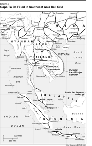
The Kunming-Singapore Rail Corridor
The Southeast Asian countries have clearly recognized that the lack of an efficient and comprehensive regional rail network presents a principal obstacle to their economic development (Figure 8). On the one hand, many of the existing lines are relics of the colonial period, and must be modernized. On the other, there are no rail connections at all among Vietnam, Laos, and Cambodia. A single line connects Malaysia with Thailand and Singapore, and southern China with Vietnam. In the eastern direction, the railroads in Myanmar stop several hundred kilometers away from its borders with Bangladesh and India.
 |
||
As the first priority in the coming years, the Association of Southeast Asian Nations (ASEAN) countries will fill the following gaps in the regional rail network: 48 km from Aryanprathat to the Thai-Cambodia border at Sisophon (the existing line was destroyed by the Khmer Rouge); 263 km linking Thailand to Myanmar; and 585 km linking Laos to Vietnam.
In addition, there is the key project of creating a continuous connection from Singapore to southern China: the much-discussed Singapore-Myanmar-Kunming Railroad (SMKR). By decision of the ASEAN heads of state, and government a feasibility study is being carried out. This was to be presented to the ASEAN governments in mid-2001, and an announced decision in favor of the projects is expected. The probable route: Singapore-Kuala Lumpur-Bangkok-Three Pagodas Pass-Ye-Yangon-Lashio-Ruili-Kunming.
The Longest Bridge In South Asia
Almost unnoticed by the Western press, the longest bridge ever constructed in Southern Asia, was opened in Bangladesh on July 23, 1998. The 4.8 km combined road and railroad bridge traverses the great Jamuna River—the lower reach of the Brahmaputra River within Bangladesh, which practically divides the country in two. The bridge also carries high-voltage cables, a natural gas pipeline, and fiber-optic cables for communications and data transmission.
Since the opening of the Jamuna Bridge, numerous improvements have been made in the transport network of Bangladesh, contributing to the development of a southern corridor from Myanmar via Pakistan and Iran to Europe (Figure 9 and Figure 10). In 2001, a new 134 km railroad connection from the Jamuna Bridge to the capital, Dhaka, will be completed. Important additional lines will be added to the already-existing east-west connections in Bangladesh, to make the stretch accessible to both of the main track-gauges used in the region. These are the 1,676 millimeter gauge predominant in India, and the 1,000 mm gauge used in Myanmar, Thailand, and Malaysia.
A further, not insignificant breakthrough occurred in July 2001, when, for the first time in 36 years, passenger rail traffic was resumed between India and Bangladesh. Railroad traffic had been broken off in 1965 for political reasons. First, in 2000, freight traffic on the route Calcutta (India)-Bangabandhu (Bangladesh), began; and now follows passenger service with the Maitry Express (Maitry means "friendship").
Now, there are two options for making India accessible by rail from South Asia: either to fill in the missing link between Bangladesh and Myanmar, or to build a direct connection in the north, from India's eastern state of Assam to Myanmar.
The New North-South Corridor Russia-Iran-India
On Sept. 12, 2000, the transportation ministers of Russia, Iran, and India signed an historic agreement for the development of a highly efficient north-south transportation corridor, which will raise economic cooperation to these three nations to a new level. The agreement establishes a combined land-sea corridor (Figure 11). Freight from India to Russia, for example, will, first of all, be transported from the western ports of India by ship to the Iranian port of Bandar-e Abbas, and thereafter via the railroad lines completed in 1995 to Bandar-e Anzali on the Caspian Sea. From Bandar-e Anzali, the ship route goes to the great Russian port of Astrakhan, and then by railroad or truck to destination points in Russia, or further on to Europe.
This corridor is, not least of all, interesting for transport between northern Europe and India, as an alternative to the usual sea route; thereby, the long detour through the Suez Canel is eliminated, shortening transportation times considerably. Transport costs could be reduced by 20-25%, or more. Here, again, the inherent economic advantage of land-corridor transport, relative to pure maritime transportation routes, can be exploited: namely, that economic development in the regions along the transport route increases the overall benefit of the corridor many times over.
Incidentally, this north-south transport route itself is not new, but coincides with the traditional "Tea Road" from India. However, the efficiency and speed of transport can now be drastically increased, thanks both to the modernization of transportation technology, and the now agreed-to creation of a unified entity, which will be responsible for overall transport logistics in the corridor.
In order to promote the development of the North-South Corridor and other Eurasian transport corridors through Russia, the Russian Transport Ministry, with the agreement of 40 European and Asian nations, founded the Eurasian Transport Union (EATU) in May 2001.
Iran As Focal Point Of The Southern Corridor
Like Persia in the time of the old Silk Road, Iran has grasped its strategic location at the crossroads of Eurasian infrastructure corridors both in the east-west and north-south direction. Iran is the natural hub for land transport between Europe and Asia, across Turkey, the Caucasus, Central Asia, and the Indian Subcontinent, while at the same time, offering an efficient gateway for Russia and Central Asia, by way of the Iranian port cities, to the Persian Gulf and the Arabian Sea.
In EIR's 1997 Special Report on the Eurasian Land-Bridge, we detailed the remarkable recent developments of the Iranian railroads, which concretized this role as a Eurasian hub (Figure 12). At present, construction work is proceeding on a project of especially great historical and strategic significance: a railroad connection from the Iranian city of Kerman up to the border with Pakistan. Thereby, the Indian Subcontinent will be directly linked by rail to Europe for the first time in history. According to reports, work is now proceeding on 6 of 24 sections, while on the Pakistani border at Mirjaveh, a modern freight terminal is being built up. With the completion of the project, the entire line from Europe to Mirjaveh will be continuously traversible in European standard track gauge.
At the same time, since the beginning of 2001, regular passenger and container train service has been established on the Istanbul (Turkey)-Ankara-Tabriz (Iran)-Teheran-Mashhad-Tedzhen (Turkmenistan)-Tashkent (Uzbekistan)-Almaty (Kazakstan) line. This is occurring by agreement among ten nations of Central Asia and the Near East, with the support of the Economic Cooperation Organization (ECO).
Despite the attempts of the Anglo-American geopoliticians to play Turkey against Iran, economic relations have continued to develop between the two nations. After eight years, regular rail transportation between Istanbul and Tehran has been resumed, including the Lake Van Express. Interestingly, in July, natural gas from Iran began to flow into Turkey, in fulfillment of a 1996 agreement, according to which Iran is supposed to supply Turkey with natural gas valued at $20 billion or more over the next 20 years.
Turkey has also, in 2001, resumed rail traffic with Syria and Iraq. Syria and Iraq agreed in September 2000 to establish regular rail connections between Damascus and Tehran, across Turkish territory.
New Rail Technologies Overcome Obstacles
As a sign of the increasing trans-Eurasian rail traffic, solutions are being developed for the problem of different track gauges of existing railroads in different regions. One of the main problems is posed by the transition between the normal European gauge of 1,435 mm, also used in Turkey, Iran, and China, and the gauge width of 1,520 mm used on the territory of the former Soviet Union. In order to avoid the time-consuming reloading operations at the junctions between the rail systems, a variety of new container-carrying platforms are being developed, which can run on both gauges. The International Railroad Union (UIC) is working on such cars, which are designed to operate at higher speeds than the existing ones. The same approach can be applied to other gauge-change points in the emerging Eurasian rail system.
Tunnel Under The Bosphorus
The Bosporus is the needle's eye of the Southern Corridor between Europe and Asia. Since August 1999, the so-called "Marmaray" project has been fully under way: building an underwater tunnel for freight and passenger trains, between the European and the Asian sides of the Bosporus. The tunnel, whose realization has enjoyed substantial financial support from the Japanese Overseas Economic Cooperation Fund, has an earthquake-secure design consisting of 18 sections. The project is supposed to be completed by the end of 2005. It is expected that in 2015, up to 65,000 people hourly will cross through the tunnel in each direction. The freight capacity of the tunnel corresponds to 10-12 highway bridges.
Several other projects have been launched in the framework of the Pan-European Transport Corridor IV, with a view toward improving the infrastructure connections from Central Europe over the Balkans to Asia. Among others, a new bridge will be built over the Danube in Bulgaria. All told, 16.8 billion euros are projected to be invested in the improvement of transportation infrastructure (railroads, highways, harbors, and so forth) in this corridor. Corridor IV includes the connections between the cities Dresden-Nuremberg-Prague-Vienna-Bratislava- Budapest-Constanza-Sophia-Thessaloniki-Plovdiv-Istanbul.
The Trans-Asiatic Pipeline Network
Besides rail and road transport, energy production and distribution infrastructure play a central role in the development of Eurasia. In the last 24 months, a large number of projects have been launched, which, taken together, lay the foundation for creating a unified energy network for the entirety of Eurasia.
The main emphasis today lies on tapping the huge crude oil and natural gas reserves in Central Asia, Siberia, and the Russian Far East (including Sakhalin), as well as on great projects for the construction of pipelines to Western Europe and East Asia. These projects, together with very promising developments in the sphere of nuclear energy, signal the beginning of the end of an era: Soon, the oil-producing countries of the Middle East—and the Anglo-American interests which stand in close connection to them—will no longer be able to dominate the energy supply of the world in the same degree, as has been the case since the 1960s.
We will concentrate our attention here primarily on East Asia, where the foundations for a "trans-Asian pipeline network" are already being laid, with participation of Russia, Japan, China, South Korea, and other nations.
Today, 85% of the combined crude oil consumption of the Asian countries is imported from the Persian Gulf region. Practically 100% of these crude oil imports are transported by sea. Japan and South Korea, which possess hardly any sources of their own, import 90% of their crude oil and natural gas from the Middle East. Japan, South Korea, and China together consume 78% of the worldwide exports of liquefied natural gas (LNG). China, which has undertaken great efforts to open up its own mineral resources, and which has thereby become one of the largest oil-producing countries, must still import from the Middle East 62% of its rapidly growing consumption. India is even less favored with concentrations of these natural resources, and must also import the major part of its consumption. Only a few countries in Southeast Asia, notably Indonesia and Malaysia, have significant established crude oil and natural gas sources.
It has long been known that Eastern Siberia and the Russian Far East dispose of gigantic natural gas and oil resources. Until now, however, these resources were only very marginally developed. This circumstance was connected with the harsh climatic and geological conditions, as well as the great distances and the lack of infrastructure in those regions, plus the fact that the overwhelming majority of the population of Russia and the former Soviet Union, were concentrated in the far-distant western regions. Today 78% of the crude oil production of Russia (approximately 300 million tons per year) and 87% (approximately 500 billion cubic meters per year) of the natural gas production of Russia is based in Western Siberia. The pipeline network of the Russian Federation, built in Soviet times, serves primarily the objective of distributing West Siberian oil and natural gas in the western part of the country, and (particularly in the case of natural gas) exporting them to Europe—which has multiple connections to the Russian pipeline network.
Japan, as the largest Asian consumer, up to now, of oil and natural gas, has long been interested in the energy resources of the East of the Soviet Union. In the Cold War period, however, Japan was strongly bound to the Western alliance and the United States; a significant dependence upon Russian energy supplies was unthinkable, as also in the case of South Korea. The tense relationship between China and the Soviet Union since the 1960s also contributed to a situation, in which the development of the energy resources of eastern Russia received relatively little attention. Thus it came about, that up to today, no pipeline connections exist from the territory of Russia to the East Asian countries.
With the end of the Cold War and the economic rise of Asia, and above all of China, this situation has dramatically changed. The crude oil and natural gas resources of the Russian East have acquired new significance.
The Kovyktinsk fields near Irkutsk have "proven or probable" reserves of 1.4-3 billion cubic meters of natural gas, while the Chayadinsk natural gas fields in the Sakha Republic (whose capital is Yakutsk) possess about 1 billion cubic meters. The Sakhalin offshore natural gas fields have "proven or probable" reserves of approximately 1.8 billion cubic meters. These amounts surely represent only a fraction of the actually existing resources in East Siberia and the Russian Far East.
By comparison, China—where government policy projects a significant increase in the relative share of natural gas in the future energy system of the country—will import an estimated 120 billion cubic meters of natural gas per year by 2020. Evidently, Russia could supply a great part of this in the coming decades (Figure 13).
The present plans of the Russian natural gas firm, Gazprom, foresee the construction of least four major natural gas pipelines to East Asia in the coming period: 1) from the Tomsk region in northwest Siberia to Northern China; 2) from the Irkutsk region in the south-central region of Siberia, across Mongolia to Central China (already mentioned); 3) from Yakutia in northeast Siberia, along the eastern, coastal, rail line of China to Shanghai; and 4) from Sakhalin Island to Japan.
At the same time, China is building a pipeline from the Tarim Basin in western Xinjiang province, from west to east roughly 4,000 km diagonally across China, as a great project in the framework of the Chinese government's Tenth Five-Year Plan.
At the same time, in the North Korean capital of Pyongyang, an expert seminar recently took place, on the construction of a gas pipeline from the Chinese border through North Korea to South Korea. This pipeline is supposed to be the continuation of a projected gas pipeline from the Kovyktinsk natural gas fields near Irkutsk, to China. The latter Russian-Chinese pipeline is scheduled to go into operation in 2008.
A similar situation holds for oil. On Sept. 9, 2001, China and Russia signed an agreement to build a 2,400 km pipeline between Irkutsk and Northwest China. The pipeline is to transport 20-30 million tons of crude oil to China.
One of the other centers of gravity of international energy cooperation, is the ongoing project for tapping the offshore gas and oil fields of Russia's Sakhalin Island, in the Sea of Okhotsk, whose proximity to Japan and other markets in the Pacific makes such a project especially attractive. There are seven projects for the exploitation of natural gas and oil around Sakhalin. Investments on the order of magnitude of $25-45 billion in the transport and production infrastructure of the island, are planned for the coming 20 years.
In 1999, the first crude oil flowed from the "Sakhalin 2" project. In 2002, large-scale projects will begin for the development of harbors and other transport facilities on Sakhalin. The construction of an "energy bridge" between Sakhalin and Japan is also under consideration: According to this scheme, electric power will be generated in giant gas-powered plants near the natural gas sources in Sakhalin, and transported to Japan via undersea cables.
In the long run, what will count is not the energy resources alone, but rather the general development of Sakhalin as part of an infrastructure corridor, which will link Japan to the Eurasian mainland (discussed above).
The current projects constitute only the first steps toward development of a "trans-Asiatic pipeline network"—as this has been proposed for many years, by Japan especially, as the largest crude oil and natural gas importer of Asia. According to Japanese energy expert Masaru Hirata of the University of Tokyo, the trans-Asiatic pipeline network, now in its beginning stages, should reach an overall length of about 42,500 km (26,000 miles, equal to the Earth's circumference), and comprise the following primary corridors: 1) North Asia (East Siberia and Russian Far East)-North Pacific; 2) Turkmenistan-China-Korea-Japan (three different possible routes); 3) Sakhalin-Japan (with possible connection to Alaska); 4) Malaysia-Gulf of Thailand-Vietnam-South China; and 5) Australia-Southeast Asia.
In South Asia, a very important pipeline project is under negotiation, from Turkmenistan across Pakistan to India. In addition, a variety of new pipeline projects have arisen, running from the crude oil and natural gas fields around the Caspian Sea, to Europe. These have unfortunately become the subject of a dangerous geopolitical chess game, which has little or nothing to do with the real interests of the nations of the region.
But rather than go further into the infrastructure of fossil energy transport, we turn our attention now to the ultimately much more important sphere of nuclear energy.
Nuclear Energy On The March
One kilogram of nuclear fuel in an atomic reactor generates about as much energy as the combustion of more than 50 tons of petroleum! In that fact, we begin to grasp the vastly higher economic potential of nuclear energy, compared to fossil fuel technology. In Western Europe and the United States, the once-mighty nuclear industrial sector is threatened with extinction, thanks to the media-driven anti-nuclear hysteria in the population and institutions. But in Asia, nuclear energy is in the beginning phases of a vast upsurge.
Characteristic of this development is the fact, that nuclear power plants have become an "export champion" of an otherwise depressed Russian machining industry. At present, Russia is building six large nuclear power reactors abroad: two nuclear reactors in China (Tianwan 1 and 2 at Lianyungang, Jiangsu Province); two nuclear units in India, at Kudal; and two reactors in Iran, at Bushehr.
A whole series of further projects is under discussion. Nuclear power is making a comeback in Russia itself: The nuclear energy plant Rostov 1 went on line in 2001; three additional nuclear units are now under construction, and nine others are planned by 2010. Beyond this, the Russian Ministry of Atomic Energy has drawn up a comprehensive plan for the development of nuclear power, according to which the relative share of this energy source in the total energy generation of the nation will increase dramatically over the coming 20 years.
China is also opting for a large-scale expansion of nuclear power. Although that nation possesses enormous reserves of coal, the annual mining, distribution, and burning of over a billion tons of coal per year creates an enormous burden on the transport system and the environment, and drags down the physical productivity of the Chinese economy. For that reason alone, a broad utilization of nuclear energy is inevitable. There are now eight large nuclear power reactors under construction: Qinshan 2, 3, 4 and 5; Lingao 1 and 2; and Tianwan 1 and 2.
These projects will all be completed by 2005. Additionally planned are two 1,000 megawatt (MW) reactors at Haiyang, while four additional units for Hui An, Fujian, Sanmen, and Zhejiang are under study.
In South Korea, two nuclear power plants are under construction, and the construction of an additional 12 units is planned by 2015. Japan projects the construction of an additional 20 large nuclear reactors.
India plans 12 additional nuclear energy plants. Even Vietnam is planning the construction of a first nuclear power plant by 2020, in its long-term government program. Indonesia, while a major petroleum-exporting nation, has also been studying the possible domestic applications of nuclear power.
The High-Temperature Reactor Is Coming
At the beginning of 2001, in the vicinity of China's capital, Beijing, a unique nuclear reactor was put into operation, which is destined to play a key role in the development of the Eurasian infrastructure corridors . This is the "pebble-bed" high-temperature reactor (HTR), first developed in Germany. After decades-long, highly successful operation of the first HTR test reactor AVR in Jülich, and the construction and operation of a 500 MW HTR power plant at Hamm-Uentrop, this revolutionary technology became the victim of the politically manipulated hysteria against nuclear energy in Germany. The pebble-bed reactor subsequently emigrated—exactly like the German-developed Transrapid—to China, and (see below) also to South Africa.
In the Institute for Nuclear Energy Technology (INET) of the Chinese Tsinghua University, the HTR was realized in an especially promising form for worldwide application. The 10 MW Chinese HTR-10 is the prototype of a standardized modular reactor of approximately 200 MW-thermal capacity, which can be mass-produced at low cost in the future. On account of its simple construction and operation, inherent safety, small unit-size, flexibility, and ease of maintenence, this reactor is eminently suited for use in developing nations.
Apart from China, these advantages of the HTR have moved the large South African electric power company, ESKOM, to launch an ambitious program for the development and assembly-line production of HTR modules. ESCOM plans, after the success of a first, prototype project, to produce 30 modules every year: 10 for internal consumption and 20 for export. The Chinese HTR-10, already in operation, is supplying important advance data and practical experience for the South African program. In the area of HTR development, a comprehensive international cooperation has emerged in recent years, with the participation of China, South Africa, Germany, France, Russia, and the United States.
The core of the HTR-10 consists of a graphite-lined cylindrical chamber of 1.8 meters diameter, filled with 27,000 spherical fuel elements ("pebbles"), each the size of a tennis ball. Each fuel "pebble" contains about 8,300 tiny particles of enriched uranium, about the size of a grain of sand, embedded in a graphite matrix. Each particle is encased in concentric layers of a high-temperature ceramic (silicon carbide) and carbon material.
The idea of such "coated particles" is that the radioactive substances which are generated by nuclear fission reactions, are permanently trapped within the particles themselves, and cannot escape to the environment. The fuel elements are so constituted, that they withstand even extreme temperatures—up to 1,000°C in normal operation, and even peak temperatures of 1,600°C in the event of a failure of the cooling system—without any considerable quantities of radioactivity escaping to the outside. In addition to this, the fuel pebbles permit a continuous fueling of the reactor. This eliminates the need to interrupt power operation for several weeks for fuel reloading, as is the case with conventional reactors. In the HTR, fuel pebbles are continuously fed in from the top of the reactor, while old ones are gradually removed from the core via its funnel-shaped bottom.
Through the use of ceramic, "sealed" fuel pebbles, it is possible to greatly simplify the entire construction of the reactor, making it inherently safe under all conditions. An accident leading to dangerous escape of radioactivity to the environment is precluded in this reactor, because of its special physical characteristics—above all, the "trapping" of radioactive products in the fuel elements up to high temperatures and the strong "negative temperature co-efficient," which prevents a "runaway" power increase in the reactor. The HTR does not need the intricate, expensive safety systems that are required for conventional nuclear power plants. Yet, this is only one of its many advantages.
A decisive breakthrough over conventional nuclear technology lies in the fact, that the HTR has a much higher operating temperature—900°C, or more. Therefore, the HTR can not only reach a higher thermodynamic efficiency in the generation of electric power, but can also serve as an economical source of process heat for various chemical and other industrial processes. Among these are the environmentally friendly generation of fuels such hydrogen and methanol from natural gas; coal gassification; process steam generation, metallurgical processes, and so forth.
Where conventional nuclear plants are only suited to, and designed for, delivering electrical power, the HTR can be employed in many more sectors of the energy economy, where energy is needed directly in the form of heat. HTR process heat can replace a part of the costly and environmentally damaging burning of coal, oil, and natural gas.
Chinese experts have in mind, among other things, to use HTRs for generating high-temperature steam, whose injection underground can make it possible to exploit major heavy oil deposits in the country.
In a first period, the heat generated from the Chinese prototype HTR-10 will only be utilized, with the help of a conventional steam generator and a turbine, to generate electrical power. INET plans later to install a compact helium turbine in the primary cooling cycle, in order to explore the possibilities for a very much simpler, and at the same time more efficient conversion of reactor heat into electricity. There are also various possibilities for tapping the HTR's waste heat. The helium turbine plays a large role in the plans of the South Africans, who hope to be able to produce electricity at extremely advantageous cost of about 1.6 U.S. cents per kilowatt-hour.
The majority of the components of the HTR-10 were produced in China itself, including the reactor vessel, steam generator, and the helium cycle cooling system. Exceptions are the graphite structures for neutron moderation in the nuclear reactor. The special graphite was imported from Japan; the precision machining of the material was done, however, in China.
Projects for Seawater Desalination With Nuclear Energy
Increasing shortage of freshwater has, in many regions of Eurasia and the world, become a serious economic and—as the case of the Middle East shows most explosively—also political problem. Conversely, the dry and desert areas of Eurasia could be turned into gardens, if we were in a position to efficiently produce sweet water from the practically limitless quantities of easily available salt water of the ocean and seas of the world (including inland salt seas such as the Caspian Sea).
There are today several well-established industrial processes for the desalination of salt water, processes which are constantly being improved, and which are already exploited in large scale, in Saudi Arabia and some other countries, for the supply of drinking water. All these processes use large quantities of energy, and providing the required energy makes up a large part of the overall cost of the water produced per cubic meter.
For this reason, the possibility of using nuclear energy has long been considered. On the basis of modular nuclear reactors, highly productive "nuplex" centers can be built—agroindustrial complexes which combine electricity production, desalination, artificial fertilizer production, and other industrial processes, together with the most modern irrigation and other agricultural techniques. Only recently, however, have concrete projects been launched, which could lead to a worldwide breakthrough for nuclear desalination.
In December 2000, China and Morocco signed an agreement on building a nuclear-powered seawater desalination facility near Tan Ten in southern Morocco. According to the agreements, China will provide a 10 MW nuclear reactor, developed specifically for the production of low-temperature heat for desalination processes and other uses, at the Institute for Nuclear Energy Technology (INET) of Tsinghua University. This small reactor was specially designed for safety, reliability, and ease of operation, with a view to use in developing countries. The facility in Morocco, which will be constructed in cooperation with the International Atomic Energy Agency (IAEA), should produce 8,000 cubic meters of freshwater daily, enough for the water consumption of more than 70,000 people. If the project works out successfully, similar facilities will be set up elsewhere in Morocco and in other countries. At the same time, a large facility for seawater desalination on the basis of nuclear energy, is planned in China itself, to be built on the Pacific coast in the vicinity of Dalian.
The possibilities of desalination have been raised more and more frequently in China, in the framework of expert discussions on the solution of water shortage problems in the dry north of the country. For the western regions, the transfer of large amounts of water, with the help of pipelines, canals, and pump stations, is foreseen; but for the eastern region around Beijing, it appears that desalination may be more favorable in cost, than bringing in additional large quantities of sweet water from great distances. Scientists at the Beijing Institute of Nuclear Engineering are presently investigating the economic advantages of very large nuclear desalination sites. They are studying facilities with capacities of up to 100 million or more cubic meters per year, which could cost-effectively secure the water needs of large population concentrations in the northeast of the country.
The Era Of The Maglev Begins In China
On Jan. 23, 2001, the German-Chinese contract was signed, for the building, in Shanghai, of the first commercial magnetic-levitation rail line in the world.
It is of greater importance, that at the moment when the creation of a new, integrated Eurasian transport network has become necessary, a revolutionary new transportation technology stands ready at hand, one whose characteristics ideally meet the requirements of high-speed transportation in and between Europe and Asia. This is magnetic levitation technology, which is not only suited for passenger travel at velocities up to 500 km/hour—for which the German maglev system Transrapid was optimized—but in the future will also allow the creation of fully automated systems of freight transport, with performance parameters which up to now are completely unattainable. Such future freight systems will automatically transport containers from one chosen spot on the network to another, like a computer-controlled industrial conveyor belt. At speeds of up to 250 km/hour, a single maglev contain freight transport line could support as much freight daily, as 20 or more parallel conventional railroad lines.
With the Transrapid, the ancient invention of the wheel is for the first time becoming obsolete. There is no longer mechanical contact between train and track; instead, the train is suspended and propelled forward by electronically steered magnetic fields alone, in a friction-free manner. As a result, magnetic levitation technology allows, in comparison with conventional wheel-track technology, a much greater rate of acceleration, steeper ascents, narrower curves, low noise volume, higher safety because of fully automatic operation, and greatly reduced wear-and-tear on the train and roadway.
The significance of the rail-travel speed of magnetic-levitation technology, for the integration of Europe as far as Moscow, is demonstrated impressively by these realistic travel timetables, drawn up for a European Union study on "The Application of the Transrapid in Europe" ( Figure 14).
It is obvious, that the travel times of the Transrapid even for such longer routes, as from Berlin to Moscow or Kiev, can compete with air transportation; above all, if one keeps in mind the transfer time between airports and city centers, and the lengthy checking-in and boarding procedures of air travel. At the same time, the Transrapid system has all the normal advantages of passenger railroads: above all, that not only the terminal points of a line, but rather an entire series of cities in between are serviced by the same train, with the unlimited possibility of stopovers for the passengers. The Transrapid thereby contributes to the general development of the entire corridor. Whereas for an airplane there is only uninhabited, empty air between takeoff and destination.
This splendid perspective of the Transrapid for the development of Eurasia explains why this technology was targetted, in Germany itself, by the same perfidious machinations that previously sabotaged the HTR, as well as numerous other strategically decisive technologies. No one can have any doubt about the fact, that the oligarchical enemies of Eurasian development are to a large extent behind the curiously self-destructive tendencies of German politics, media, and industry, in this regard. In the case of the Green Party, this is easy to document. Thus it happened, that the planned construction of a Transrapid link from Berlin to Hamburg—which was supposed to demonstrate the commercial feasibility of this technology for the whole world—was finally dropped, after a tug-of-war that lasted years.
The cancellation of the maglev in its own birthplace would have meant the end of this revolutionary technology, were it not for Chinese Prime Minister Zhu Rongji, a trained electrical engineer, who was fascinated by the Transrapid technology, and who knew how to assess its great significance for China. With China's large population density, high density of major cities, and complicated terrain, the maglev is a crucial alternative to the kind of wasteful overloading of passenger aircraft traffic, typified by the U.S. East Coast air corridors. In addition, large-scale maglev projects will greatly stimulate the high-technology industrial sectors in China itself.
After the visit of Zhu Rongji and a likewise enthusiastic mayor of Shanghai to the Transrapid test-track in Emsland, Germany, the decision came down from the Chinese side, to build an initial 36 km Transrapid route in Shanghai. This line will connect the new international airport in Shanghai's Pudong Industrial Park, with the Long Yong metro station in the Shanghai financial district Lujiazui (Figure 15a). At peak speeds of 430 km/hour, today's travel time of 40-45 minutes (buses or cars) will be reduced to merely 7 minutes! In 2005, they expect 10 million passengers, and 21 million by 2010. The total cost of the project runs to about $1 billion. In addition, the Transrapid line, due to its elevated construction above ground, is actually cheaper to build than a corresponding conventional metro underground rail line.
The Transrapid vehicles, control and energy systems, will be supplied by Germany, while the tracks will be assembled primarily from components and equipment produced in China. The Shanghai-Pudong line should be completed by the end of 2002, for testing and approval to go into commercial operation in 2003.
In Shanghai it is being considered, after the inauguration of the Shanghai-Pudong magnetic rail line, to continue this line for a further 180 km in a southerly direction to Hangzhou, one of the most beautiful cities in the world, and a great tourist attraction in China as well as abroad. There are, however, many more, still larger projects under discussion, which point in the direction of a national magnetic rail network in China (Figure 15b).
Prime Minister Zhu Rongji has repeatedly pronounced his view, that he prefers the Transrapid technology for the planned 1,300 km high-speed connection between Shanghai and Beijing, over the competing conventional high-speed rail technologies (the French TGV, the German ICE, and the Japanese Shinkansen). But the final decision depends upon the success of the Shanghai-Pudong line.
Yet, a second Transrapid project is already decided upon in China, according to Chinese reports: namely, the building of a relatively short (about 27 km) connection between the Beijing Airport and the future Olympic Village in the northern part of the city where the 2008 Olympic Games will take place. It is also being discussed, to extend this line southeastward toward Tianjin (about 100 km).
On Aug. 16 the China News Service reported that the government of Hong Kong is negotiating with the mainland government on future magnetic levitation train connections between Hong Kong and Guangzhou (Canton), roughly 140 km, as well as with Shanghai, Beijing, and other large cities of China. In the press release it is stated that with maglev technology, the travel time from Hong Kong to Beijing (about 2,000 km) can be reduced from today's 31 hours on conventional railroad, to only 5 hours. With that, many airline passengers would switch to the maglev.
The Eurorapid
As soon as Chinese decision had been confirmed, the Transrapid suddenly began to be discussed in Germany and Europe again. Interesting, in this connection, was a Transrapid seminar held on July 10 in Hamburg. There, a "Eurorapid" network was envisioned, which would join Germany with the Netherlands, Scandinavia, Poland, and the Czech Republic.
At the seminar, there was report of a rather far-advanced Dutch plan to build two important Transrapid lines: 1) a "great belt line," which would link Amsterdam with The Hague, Rotterdam, and Utrecht; and 2) an Amsterdam-Groningen link, with an eventual extension to Hamburg.
On July 12, the Dutch Ministers of Transport and Environment made their support for these Transrapid projects known. The first project will probably be a line from Amsterdam to Lelystad.
That same day, the German state of North Rhine-Westphalia announced a joint project with the Deutsche Bahn (German Rail Corporation), to prepare a first "Metrorapid" project: a Transrapid line to run between Dortmund and Düsseldorf. Later, the Metrorapid is supposed to connect a total of eight cities in the Ruhr region with one another.
Interest in the Transrapid is also rising again in Bavaria. The Bavarian government announced on July 13, that it wants to build, together with Deutsche Bahn, a 30 km Transrapid link between the airport and the inner city of Munich.
[1] The Eurasian Land-Bridge: The "New Silk Road"—Locomotive For Worldwide Economic Development (Washington, D.C.: EIR News Service, Inc., January 1997).
[2] "The Ishayev Report: An Economic Mobilization Plan for Russia," EIR, March 2, 2001.Physical Economy- Main Page (includes links to other maps)
Eurasia Landbridge Panel of 2001 European Conference
Scroll down to bottom of page for more links on this site
schiller@schillerinstitute.org
The Schiller Institute
PO BOX 20244
Washington, DC 20041-0244
703-297-8368
Thank you for supporting the Schiller Institute. Your membership and contributions enable us to publish FIDELIO Magazine, and to sponsor concerts, conferences, and other activities which represent critical interventions into the policy making and cultural life of the nation and the world.
Contributions and memberships are not tax-deductible.
VISIT THESE OTHER IMPORTANT PAGES:
Home | Search | About | Fidelio | Economy | Strategy | Justice | Conferences | Join
Highlights | Calendar | Music | Books | Concerts | Links | Education | Health
What's New | LaRouche | Spanish Pages | Poetry | Maps
Dialogue of Cultures
© Copyright Schiller Institute, Inc. 2001. All Rights Reserved.